Showing posts with label Geology. Show all posts

Wednesday, July 8, 2009

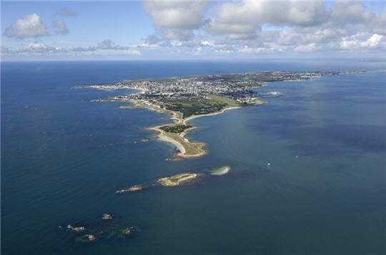
Côte Sauvage. Wild Coast of Quiberon Peninsula.

The Quiberon Peninsula was originally an island and has been joined to the mainland by the accumulation of sand washed up by the sea. Its wild scenery - particularly impressive along the Côte Sauvage on the western side - attracts many visitors. The cliffs are made up of two-mica granites. Geologists have newly interpreted the Quiberon area in the Variscan belt of South Brittany (France) as a crustal shear zone and have postulatred Carboniferous extension tectonics as evidenced by normal faults, high- and low-grade migmatites and synkinematic emplacement of the Quiberon granite pluton. Quiberon is a well-known seaside resort and has some attractive beaches on the sheltered eastern coast.
Read more about Quiberon:
- Rapid Variscan exhumation and the role of magma in core complex formation: southern Brittany metamorphic belt, France
- Armorican Massiv Geological Map
- Quiberon peninsula

Tuesday, February 10, 2009

Rhine Falls.

Glaciation and warm interglacial periods of the past 500'000 years have shaped the landscape from the high rising Alps down to the northern lowlands of Switzerland. In the area of Schaffhausen the river Rhine has changed its course several times eroding Jurassic limestone and filling channels with gravel and sand. At the location of the famous Rhine waterfall the present-day river bed consists at the upper side of hard Jurassic (150 million years old) limestones which terminate in a cliff bordering gravel beds of an abandoned river channel formed by the ancient Rhine during Riss age (about 120'000 years old). The waterfall developped about 15'000 years ago, after the new Rhine started to erode the soft Riss-age gravel and sands.
Literature:
Albert Heim, 1931, Geologie des Rheinfalls.
Der Rheinfall, Neujahrsblatt der Naturforschenden Gesellschaft Schaffhausen, Nr. 39, 1987.
http://www.knill.com/Rheinfall/Wissen/Geologie.html
http://www.rua.ch/rhein/Region03Destination01Entstehung.htm


The Rhine Falls are the largest waterfalls in Europe.
Latitude: 47.677871
Longitude: 8.614482
Google
Panoramio
Photo Stadtarchiv Schaffhausen

Sunday, January 18, 2009

Mount Etna Erupts

Friday, January 16, 2009

Etna eruptions 2006

Mount Etna is one of the most active volcanoes in the world and is in an almost constant state of eruption. The volcano dominates the landscape of NE Sicily. Etna has created a beautiful landscape and has great ecological interest.
Ein
Deutscher Fotograf stirbt auf dem Ätna. Thomas Reichert ist am Aetna ums Leben gekommen.
Thomas Reichert, a hobby volcanologist and photographer, died at the Etna volcano 32 years old. Many of his magnificent pictures can be seen on Flickr. See Fotostream von Thomas Reichart on Flickr.

Here are two films on Etna eruptions in 2006 by Thomas Reichert:


Wednesday, January 14, 2009

Volcanism at Jaujac, Ardèche, France

Outcrops of a young volcano at Jaujac village and the lava rocks are unique in the world and excite geologists and most other people.

The lava of a very young volcano has spread over the ancient river bed seen at the base of the basalt columns.

Read more about it.

Tuesday, January 13, 2009

Ozeane und Plattentektonik schon auf der Ur-Erde

Solscape Geologie: "Ozeane und Plattentektonik schon auf der Ur-Erde"
29. November 2008
Die Bewegungen der Erdkruste im Rahmen der Plattentektonik begannen schon vor vier Milliarden Jahren - und damit viel früher als bisher angenommen. Das belegen amerikanische Wissenschaftler vom Institut für Geophysik an der Universität von Kalifornien in Los Angeles anhand von Mineralien aus der Frühzeit der Erde. Auch Wasser muss es damals schon reichlich gegeben haben. [weiter]"
Link Exchange SchweizLink Exchange Schweiz (Dynamic Banner)