Wednesday, July 8, 2009

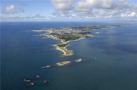
Côte Sauvage. Wild Coast of Quiberon Peninsula.

The Quiberon Peninsula was originally an island and has been joined to the mainland by the accumulation of sand washed up by the sea. Its wild scenery - particularly impressive along the Côte Sauvage on the western side - attracts many visitors. The cliffs are made up of two-mica granites. Geologists have newly interpreted the Quiberon area in the Variscan belt of South Brittany (France) as a crustal shear zone and have postulatred Carboniferous extension tectonics as evidenced by normal faults, high- and low-grade migmatites and synkinematic emplacement of the Quiberon granite pluton. Quiberon is a well-known seaside resort and has some attractive beaches on the sheltered eastern coast.
Read more about Quiberon:
- Rapid Variscan exhumation and the role of magma in core complex formation: southern Brittany metamorphic belt, France
- Armorican Massiv Geological Map
- Quiberon peninsula

Wednesday, April 22, 2009

Plateosaur Discoveries.

During the Late Triassic (about 210 million years ago) large sauropodomorphs dominated terrestrial environments.
In Europe Plateosaurs were widespread as heavy, long-necked, long-tailed herbivores up to 8 meters long.
There is a complete skeleton of a plateosaurus on display in the dinosaurs museum at Frick in Switzerland. Dinosaurs were discovered at Frick in the 1980's and 1990's at the clay quarry Gruhalde in a formation called "Bunten Mergel" (varicolored marl). In Late Triassic times the area of todays northern Switzerland was a vast, desertlike lowland with a tropical climate. Frick is one of the most important places of plateosaurs discoveries in Europe. Source: Sauriermuseum Frick.
Read more about plateosaurs:
The Anchisaur-Plateosaur Empire
The Norian Age
Dinosaurier Funde gesichert – weitere Grabungen in Frick geplant

Tuesday, February 10, 2009

Rhine Falls.

Glaciation and warm interglacial periods of the past 500'000 years have shaped the landscape from the high rising Alps down to the northern lowlands of Switzerland. In the area of Schaffhausen the river Rhine has changed its course several times eroding Jurassic limestone and filling channels with gravel and sand. At the location of the famous Rhine waterfall the present-day river bed consists at the upper side of hard Jurassic (150 million years old) limestones which terminate in a cliff bordering gravel beds of an abandoned river channel formed by the ancient Rhine during Riss age (about 120'000 years old). The waterfall developped about 15'000 years ago, after the new Rhine started to erode the soft Riss-age gravel and sands.
Literature:
Albert Heim, 1931, Geologie des Rheinfalls.
Der Rheinfall, Neujahrsblatt der Naturforschenden Gesellschaft Schaffhausen, Nr. 39, 1987.
http://www.knill.com/Rheinfall/Wissen/Geologie.html
http://www.rua.ch/rhein/Region03Destination01Entstehung.htm


The Rhine Falls are the largest waterfalls in Europe.
Latitude: 47.677871
Longitude: 8.614482
Google
Panoramio
Photo Stadtarchiv Schaffhausen

Thursday, January 29, 2009

Darwin Online.

Check out the website offering the complete work of Charles Darwin online for free > Darwin Online.
The Complete Work of Charles Darwin Online (or Darwin Online) began in 2002 to assemble in one scholarly website all of Darwin's published writings and unpublished papers. It does not cover his unpublished letters which were already the focus of the Correspondence of Charles Darwin.
Darwin Online is the largest and most widely used Darwin resource ever created. More copies of Darwin's works have been downloaded from Darwin Online than were published in Darwin's lifetime or in the whole of the 19th century.
The site contains over 74,000 pages of searchable text and 182,000 electronic images. It contains at least one exemplar of all known Darwin publications, reproduced to the highest scholarly standards, both as searchable text and electronic images of the originals. The majority of these have been edited and annotated here for the first time.

Saturday, January 24, 2009

Cave rocks reveal past climate changes.

Stalagmites have been sampled from caves in China and other caves from all over the world. Split into half, stalagmites reveal banding like an agate. The layers of calcite indicate periods of wet and dry weather and changing contents of trace elements. The bands are annual growth rings like in a tree and reveal ages of up to 100'000 years. The University of Minnesota researcher Hai Cheng measures uranium and thorium contents and reconstructs a weather and climate history. Photo shown here were taken by Hai Cheng who grew up in China, but now is a research scientist in the Department of Geology and Geophysics at the University of Minnesota.
Ref.: Ancient cave rocks reveal impact of climate change by Stephanie Hemphill

Cave gives clues to China's history.
In an article published in Science, the researchers say the stalagmite, found in Wanxiang Cave, China, told of strong and weak monsoon periods, which coincided with the rise and fall of several Chinese dynasties.
"....weak and consequently dry monsoon periods coincided with the demise of the Tang (618-907), Yuan (1271-1368) and Ming (1368-1644) dynasties."
"We have demonstrated that the cave records correlate well with many records, including the little ice age in Europe; the temperature changes in China and Northern Hemisphere and major solar variability."
Ref.: ABC Science : Cave gives clues to China's history.

Sunday, January 18, 2009

Mount Etna Erupts

Link Exchange SchweizLink Exchange Schweiz (Dynamic Banner)